IELTS Writing Task 1 Maps
Master IELTS Writing Task 1 map questions with this complete guide. Learn the key task requirements, high-band vocabulary, a Band 9 sample answer on Pentland's development, and practical tips – then practise online with instant feedback.
What is an IELTS Writing Task 1 Map Question?
A map question tests your ability to describe how a place changes over time or how two layouts compare, using clear, accurate location language rather than numbers.
What does this task test?
In IELTS Academic Writing Task 1, map questions typically show the same place at two or more points in time (e.g. 1950 vs 2007), or two different plans of a place."Summarise the information by selecting and reporting the main features, and make comparisons where relevant."
A map Task 1 tests whether you can:
- describe physical changes (what was added, removed or replaced)
- use location language (north, south, next to, along the road)
- describe functions (industrial area, residential area, recreational facilities)
- summarise overall trends (e.g. became more residential and tourist-oriented)
Assessment Criteria
- Task Achievement:Describe main changes, clear overview of trends, avoid inventing features.
- Coherence:Logical paragraphs (by area or theme), systematic description, linking expressions.
- Lexical Resource:Location phrases, change verbs, accurate place labels.
- Grammar:Simple and complex sentences, correct tenses (past simple + passive), correct prepositions.
Timing & Rules
- Recommended time: 20 minutes
- Minimum length: 150 words
- Contains: Maps with labels, compass, key/legend.
Useful Vocabulary & Sentence Patterns
To reach Band 7–9 in IELTS map tasks, you need precise location language and effective change verbs.
Cardinal: in the north / south-east, north-west corner
Relative: opposite, adjacent to, next to, to the west of
be built / constructed, be replaced by, be converted into, be demolished, expand, extend
industrial area, residential area, housing estate, marina, amenities, facilities
| Category | Examples |
|---|---|
| Location Language |
|
| Change Verbs |
|
| Nouns for Land Use |
|
| Overview Patterns |
|
Core Sentence Patterns
- Intro: "The two maps compare the coastal town of Pentland in 1950 and 2007."
- Overview: "Overall, Pentland was transformed from a largely industrial and rural area into a more residential and recreational seaside town."
- Specific Change: "The industrial area in the south-west had been removed and replaced by a public park."
Band 9 Map Sample Answer
Analyze this high-scoring response to understand structure, location language, and describing changes over time.
Sample Question
The two maps below show the coastal town of Pentland in 1950 and 2007.
Summarise the information by selecting and reporting the main features, and make comparisons where relevant.
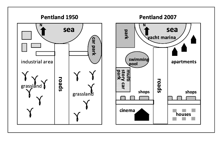
Pentland: 1950 vs 2007
- West: Industrial area (SW), Grassland, Simple car park (Seafront).
- East: Entirely grassland.
- Central: Main road dividing the town.
- West: Park (replaced Industry), Cinema, Multi-storey car park, Pool.
- East: Apartments (North), Housing estate (SE), Shops (South).
- Sea: Yacht marina added.
Planning Notes
- Overview: Industrial/Rural → Residential/Resort transformation.
- West Side: Industry → Park; Car park → Multi-storey + Cinema.
- East Side: Grassland → Apartments, Shops, Housing.
- Seafront: Added Yacht Marina.
The two maps illustrate how the coastal town of Pentland changed between 1950 and 2007. Overall, the town was transformed from a largely industrial and rural settlement into a much more residential and recreational resort, with several new facilities for both residents and visitors.
In 1950, the western side of Pentland was dominated by grassland and an industrial area in the south-west corner. By 2007, this industrial zone had disappeared and been replaced by a park, indicating a clear shift away from manufacturing. Just north of this, along the seafront, the original open car park had been redeveloped into a multi-storey car park, and a cinema had been constructed immediately to its south. A swimming pool was also added between the park and the car park, providing further leisure options.
Significant changes also occurred on the eastern side of the main road. Whereas this area consisted entirely of grassland in 1950, by 2007 it contained a row of apartments facing the sea in the north and a new housing estate in the south-east. In addition, shops were built along the southern section of the coastal road, creating a small commercial strip. Out at sea, a yacht marina was constructed, further reinforcing Pentland's new role as a tourist-oriented coastal town.
In summary, over the 57-year period Pentland underwent extensive redevelopment, with industrial land and open fields giving way to housing, shops and leisure facilities. These changes modernised the town and made it more attractive as a place to live and for holidaymakers.
Essential Writing Tips for IELTS Map Essays
Task Response
Always mention both time points and describe overall trends (e.g. "more built-up / more residential"). Avoid long stories about why changes happened.
Coherence & Cohesion
Decide on a strategy: by area (west vs east) or by theme (housing vs industry). Use linking phrases: while, whereas, in contrast, by 2007.
Language Use
Use past simple passive for changes (was built, were added, was removed). Always include location prepositions (in the north-west, to the east of).
IELTS Writing Task 1 Map Sample Answers (Band 7–9)
Present and future layout of a company site
The diagrams compare the current layout of a company and a proposed future plan with more structured office and production areas.
Road layout changes to reduce traffic accidents
The maps show how a particular road system is planned to be redesigned in order to reduce traffic accidents, with new roundabouts and separated lanes.
Current and proposed office building design
The diagrams illustrate the present layout of an office building and how it is going to be changed in the future, with more open-plan workspaces.
IELTS Writing Checker (Map & Other Tasks)
If you would like to practise IELTS Writing Task 1 & 2 (including map questions) with instant AI feedback, you can use Lingoleap, an AI-powered platform designed for IELTS and TOEFL learners.
On Lingoleap's IELTS page, you can:
- Generate and practise Writing Task 1 and Task 2 questions
- Get AI scoring and corrections on your essays, including feedback on task response, coherence, vocabulary and grammar
- Build your own bank of sample answers and vocabulary for different IELTS topics
- Combine writing practice with integrated speaking, reading and listening tools
FAQs about IELTS Writing Task 1 Maps
Do I need to describe every building and label on the maps?
No. Focus on the main changes: areas that were added, removed or completely redeveloped. Minor details can be grouped or omitted if they are not essential.
Should I use present or past tense for map questions?
Most IELTS map tasks show past developments, so you normally use past simple and past simple passive (e.g. 'was built', 'were replaced'). Use present simple only if the map clearly shows the current layout.
Is it necessary to write a separate conclusion?
A short final sentence is helpful but not essential. What matters most is having a clear overview paragraph after the introduction and covering all key changes accurately.
How is a map task different from a line graph in Task 1?
Maps show spatial changes in a place, not numerical trends. You should focus on location, land use and development rather than increases and decreases in numbers.